|
| Home | About Us | Our Network | Our Issues | Calendar | Links | Join Us |
Public Lands
|
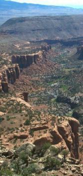
Lower Dolores River Canyon WCC is part of the Dolores River Coalition. The lower Dolores River basin near Gateway is a land of spectacular red-rock canyons and stark contrasts. This area is home to six citizen-proposed wilderness areas that provide critical wildlife habitat, diverse flora and fauna, unique cultural resources, rugged backcountry recreation opportunities and stunning red rock vistas that draw visitors from far beyond this region. The wildlands of the lower Dolores Basin are under threat from both increasing recreational use and energy development. The nearby urban centers of Grand Junction and Montrose are growing rapidly, bringing increases in the number of recreational visitors, including those using off-road vehicles. Energy development pressures have also been increasing. In recent years, the BLM has approved drilling in a large portion of the lower Dolores basin. Interest in tapping the uranium resources in the Dolores Basin has also swelled over the past two years, and the permitting process for a new uranium mill in the Paradox Valley is underway. If this mill opens, it will bring with it a surge in mining activity that will compound the mill’s threats to the region’s air and water quality. The Dominguez-Escalante National Conservation Area and the Dominguez Canyon Wilderness were made official on March 30, 2009, when President Barack Obama signed the Omnibus Public Lands Act which included other areas across the nation. This victory, the culmination of more than a decade of citizen action by WCC members and allies, secures enduring wilderness protection for 66,280 acres of Dominguez Canyon within a 209,610-acre NCA. The wilderness area is about 20 miles south of Grand Junction, on the northeastern edge of the Uncompahgre Plateau. Opportunities to be involved in the future of the NCA and Wilderness Area include:
To learn more or get involved contact Amy Montano at (970) 256-7650. Uncompahgre Plateau Restoration Since November 2007, representatives from WCC and other conservation groups have been meeting with timber industry and land management agency staff to develop a consensus on principles and specifics for a relatively large-scale forest restoration project on the Uncompahgre Plateau. Among the different forest types on the Plateau, it is the pure ponderosa pine forests that have the clearest need for active management to restore it to a more resilient, bio-diverse natural condition. Extensive logging at the end of the 1800s and climatic conditions in the early 20th century led to even-aged stands of ponderosa that are extremely susceptible to high-intensity crown fires. This Uncompahgre Plateau Collaborative Forest Landscape Restoration Project [the 9th bullet under "Vegetation/ Fuels Management Activities] entails a number of proposed treatments to restore the ecosystem to its former glory. WCC members have successfully worked:
|
To learn more or get involved contact Lee Gelatt at (970) 256-7650.
Click here for a larger version of this map of the greater Dominguez Canyons area.
|
Western Colorado Congress is an alliance for community action empowering people |
to protect and enhance their quality of life in western Colorado. |
PO Box 1931, Grand Junction, CO 81502; phone (970) 256-7650; fax (970) 245-0686 |